|
||
|
| Physical Address
1103 Highway 248 S |
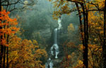
Photo Suggestions
|
|
Stop by Visitors Center and get park map |
|
|
Walk along the one mile trail (flat trail) and
photographic along the way |
|
|
Be sure to check out the old buildings along the way |
Driving Tips and Other Information
|
|
Use GPS or a mapping program to
get to the Park |
|
|
Note: From I-26 --Heading North: At the Newberry exit, take Highway 34 to the town of Ninety Six, South Carolina (about 35 miles). Turn left at the second traffic light onto Hwy 248. The park is located 2 miles south on your left. From I-26, Heading South: At Clinton (exit 52) follow Hwy 72 toward Greenwood/ Coronaca. At Coronaca, turn left onto Hwy 246/ 248 toward Ninety Six. Hwy 246 will branch off, but follow Hwy 248. The park is located 2 miles south of the town of Ninety Six on Hwy 248. From I-20 -- Take exit 5 onto US Highway 25 north. Follow the Heritage Corridor signs to Epworth. Turn right onto Epworth Camp Road. It will dead end onto Hwy 178. Turn left onto Hwy 178. Follow the park signs and turn right onto Hwy 248. The park will be about 4 miles on your right. From Interstate I-85 (Greenville) -- Take SC Highway 25 south to the stoplight at Hodges. Turn left onto Highway 246/ 248 toward the town of Ninety Six. Hwy 246 will branch off, but follow Hwy 248 to the town of Ninety six. The park is located 2 miles south of the town on Hwy 248. From the town of Ninety Six, South Carolina -- Follow the park signs. The park is two miles south of the town of Ninety Six on Highway 248. |
|
|
Check park website for operating hours and seasons |
Information compiled by Bob Spalding