|
||
|
| Physical Address
None |
|
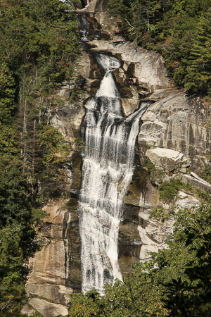
Photo Suggestions
|
|
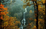
From the overlook, shoot the falls |
|
|
Suggest both vertical and horizontal |
|
|
On a bright day, watch for over exposure - maybe do a HDR |
Driving Tips and Other Information
|
|
GPS or a mapping program for
Whitewater Falls |
|
|
- From Walhalla, drive north on SC 11 (Cherokee
Foothills Scenic Highway) for 14 miles and turn left onto SC 130.
- Drive north on SC 130 for 10.5 miles and turn right (east) at the entrance to Duke Power's Bad Creek Hydroelectric Station. - Pass through the automatic gate. (Entrance onto the property is allowed only during daylight hours. Exiting the property through this gate is allowed at all hours.) - Drive approximately 2 miles to the parking area for the Foothills Trail/Whitewater River. (This is a lighted parking lot with a public telephone and portable toilets.) - From the trailhead at the far end of the parking area, walk. Follow the blue blazes of the Lower Whitewater Falls overlook spur. At 0.6 mile the spur will cross over the Whitewater River. - Turn right (northeast). At this point the spur is concurrent with the Jocassee Gorges Segment of the Foothills Trail bound for Laurel Valley. (The Foothills Trail is marked with white blazes.) - When the trail intersects a gravel road, follow the gravel road briefly (about 200 yards) and then resume your hike on the trail. A blue blaze and an arrow sign on the right point the way. - Continue to the overlook. |
|
|
Note: Most of the trail books consider the 2 mile hike into the falls a moderate hike. Be aware a moderate hike is considered someone in hiking shape. May want to limited the amount of equipment you hike in with. |
Information compiled by Bob Spalding